Sale on canvas prints! Use code ABCXYZ at checkout for a special discount!

Boundary: Bleed area may not be visible.


by Serge Averbukh
$39.00
Size
Pillow Insert
Image Size
Product Details
Our throw pillows are made from 100% spun polyester poplin fabric and add a stylish statement to any room. Pillows are available in sizes from 14" x 14" up to 26" x 26". Each pillow is printed on both sides (same image) and includes a concealed zipper and removable insert (if selected) for easy cleaning.
Design Details
Introducing �Maps - Cartography of Past and Present �collection by C.7 Design Studio, showcasing meticulous digital reproductions of various... more
Ships Within
2 - 3 business days

Digital Art

Canvas Print

Framed Print

Art Print

Poster

Metal Print

Acrylic Print

Wood Print

Greeting Card

iPhone Case

Throw Pillow

Duvet Cover

Shower Curtain

Tote Bag

Round Beach Towel

Zip Pouch

Beach Towel

Weekender Tote Bag

Portable Battery Charger

Bath Towel

Apparel

Coffee Mug

Yoga Mat

Spiral Notebook

Fleece Blanket

Tapestry

Jigsaw Puzzle

Sticker

Ornament
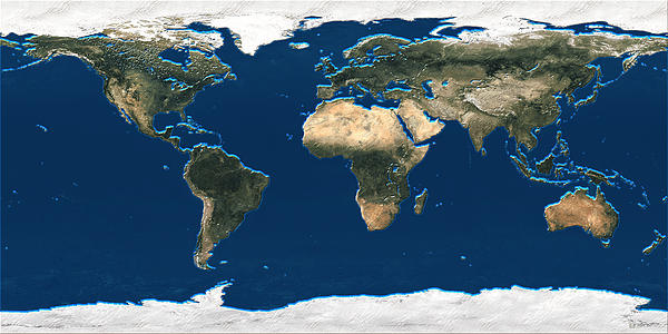
Introducing �Maps - Cartography of Past and Present �collection by C.7 Design Studio, showcasing meticulous digital reproductions of various historical and modern Geographic maps. Here you will find framed and wrapped/stretched canvas fine art prints, featuring digital painting 3D Earth at a Glance - Satellite Image of the World.
A map is a visual representation of an area � symbolic depiction highlighting relationships between elements of that space such as objects, regions, and themes. Many maps are static two-dimensional, geometrically accurate (or approximately accurate) representations of three-dimensional space, while others are dynamic or interactive, even three-dimensional. Although the earliest maps known are of the heavens, geographic maps of territory have a very long tradition and exist from ancient times. The word "map" comes from the medieval Latin Mappa mundi, wherein mappa meant napkin or cloth and mundi the world. Thus, "map" became the shortened term referring to...
Most of what you see here should be classified as new media paintings. By default, those are digitally signed and dated Open Edition (OE) giclee prints. I also offer Limited Editions of twenty one (21), which are listed here as the 'originals' (Please, contact me directly for details). Each limited edition print comes with certificate of authenticity. It is individually signed, numbered, and personally enhanced by the artist to assure its uniqueness. Those are produced using finest archival materials, and will be shipped rolled in tube, unless requested otherwise, (i.e. as framed, canvas, framed canvas, metal, etc.), in which case additional charges may apply. Briefly, about myself... A Toronto-based artist/designer/illustrator,...
$39.00


There are no comments for 3D Earth at a Glance - Satellite Image of the World. Click here to post the first comment.